Invest 99L August 25, 2016
Invest 99L is, as I write this, a mass of heavy weather with no discernible circulation positioned around Puerto Rico and Hispanola. Forecasters are frustrated by uncertainty over its future.
One computer model forecasts no development, another forecasts a major hurricane affecting the west coast of Florida. What to do?
Let’s remember Hurricane Wilma back in October 2005.
Wilma started out much like Invest 99L: a mass of unorganized squalls and windy weather in Caribbean, a bit further south than Invest 99L.

This tropical disturbance became Hurricane Wilma in October 2005.
Notice how similar the current Invest 99L looks to the precursor of Wilma:

Invest 99L satellite photo on August 25, 2016 has an uncertain future.
Wilma was the fastest forming hurricane on record.
- October 15, 2005: Erratic tropical depression between Jamaica and Yucatan.
- October 17, 2005: Tropical Storm Wilma forms.
- October 18, mid-morning: Wilma becomes a hurricane.
- October 18, 5pm: Begins period of incredible intensification.
- October 19: Wilma becomes a Category 5 hurricane with winds of 173mph within 24 hours.
Wilma broke records by having a decrease in central barometric pressure of 97 millibars over a 24 hour period and became the fastest intensifying Atlantic hurricane on record.
So don’t become complacent and wait until the last minute to pull your hurricane supplies together. Forecasters have to be careful not to cause a panic and “cry wolf” but at the same time letting people know that this storm could be dangerous.
At this point, it’s just too close for comfort, even though it does not look like much right now.
Let’s look at some differences between this current Invest 99L and both hurricanes Wilma and Charley.
Invest 99L is having to plough through the high mountains of Hispanola and Cuba. This has seriously impeded the development of this storm and could possibly prevent it from developing into a hurricane. Both Wilma and Charley formed and developed far enough south of Cuba and Hispanola so they did not spend time tangling with mountains. Below are images that show the track of Wilma and Charley.

Hurricane Wilma had plenty of time in the open and very warm waters of the Caribbean to develop into a powerful hurricane.
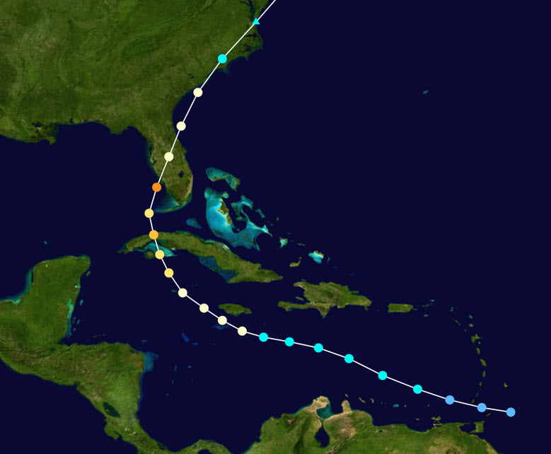
Hurricane Charley stayed well south of the large mountainous islands until it crossed Cuba and crashed into Florida. This gave it time to develop strong circulation.
What should you do to prepare if you live in Florida?
- Keep your car’s gas tank topped off.
- Have enough food in the house to last two weeks that won’t spoil and doesn’t need much (if any) cooking.
- Have enough water stored for drinking and cooking for two weeks and know how to purify contaminated water.
- Make sure you have enough of your prescription drugs and personal care products to last a couple of weeks.
- Make sure you have enough toilet tissue and soap products to last.
- Have some cash on hand. ATM cards don’t work when the power is out.
- If you have a gas BBQ grill, make sure you have plenty of propane on hand.
- Consider buying an inexpensive inverter so you can power small appliances off your car’s battery.
- Get a rechargeable battery pack for your cell phone.
- If your roof is not in the best shape, grab some large tarps and some cordage at Home Depot or Lowes.
- Prepare to evacuate if you live in an area with flood or storm surge potential.
Keep an eye on Invest 99L.